Christchurch Central, New Zealand

Christchurch Central, New ZealandChristchurch Central, New ZealandChristchurch Central, New Zealand

Luxury new 3 bdrm home | 4 beds | 2 baths

  • Home
  • Tours
  • Restoration
  • Colour Me
  • What Guests say
  • Book
  • More
    • Home
    • Tours
    • Restoration
    • Colour Me
    • What Guests say
    • Book

Christchurch Central, New Zealand

Christchurch Central, New ZealandChristchurch Central, New ZealandChristchurch Central, New Zealand

Luxury new 3 bdrm home | 4 beds | 2 baths

  • Home
  • Tours
  • Restoration
  • Colour Me
  • What Guests say
  • Book

Residential Heritage Area

Tree-lined road with a person walking on the sidewalk on a sunny day.

Chester Street East

Tree lined and a pleasure to walk down is Chester Street East. Benefitting now from street improvements completed in the 80s.

Chester Street takes its name from Christchurch’s original 1850 colonial survey, where many streets were named after major Anglican bishoprics in England. Chester, Salisbury, Hereford, Oxford, Cambridge, and Tuam are all bishopric‑derived names.


As the city grew along a strict grid centred on Colombo Street, long east–west streets were formally split into “East” and “West” to show which side of the central axis they sat on. No doubt making it easier to arrive at the right side of town before google maps.

Sunlit residential street with blooming trees and parked cars.

Dawson Lane

Land once earmarked for the Slaughter House Reserve is now a peaceful pedestrian friendly lane and home to over thirty residents.  


 The origins of this unique area, now recognised, began 160 years ago when early settler, David Clarkson, saw the need for small sections to house the city's working people so set about subdividing a large piece of land and creating a private road for access. 


 In the 1980's, the Council made major upgrades to the road to make it more pedestrian friendly. The road has had three name changes; originally 'David Street', then 'Carter's Lane', then Dawson Street...more

Chester St East / Dawson Residential Heritage Area

"All properties in the section of Chester Street East between Madras Street in the west and up to and including the Chester Street Reserve and 147 Chester Street in the east, and all properties in Dawson Street."
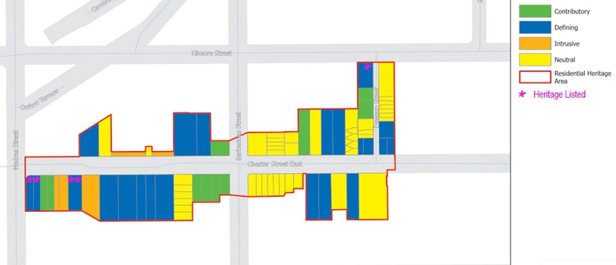
Chester St East / Dawson Residential Heritage Area

Mixed class residence

Chester Street East and Dawson Lane are now recognised for their 'special identity' as one of nine 'Residential Heritage Areas' protected in the Christchurch District Plan [Ref]. Considered a unique place of "mixed-class residence" instigated from the earliest years of colonial settlement. 


The residential houses that remain reflect the mix of people who built the city post European settlement; for example colonels, lawyers, builders, warehousemen, and lamplighters.

The origins of this unique area began 160 years ago when early settler, David Clarkson, saw the need for small sections to house the city's working people. Shortly after he purchased Town Reserve 170 he subdivided it into a private road (now Dawson Lane) and smaller sections on either side. Dwellings were rapidly erected to house city workers. This contrasts with the homes on Chester Street East between Madras and Barbadoes that tended to be larger in scale and "typically became the homes of higher-class families."


Beautification

The improvements to Chester Street East and Dawson St were part of wider initiative by Christchurch City Council to improve the environment on older hosing areas of the City, known as Neighbourhood Improvement Plans. Improvements included underground power lines, landscaping including street trees, grass berms, better footpaths and reshaped road and traffic calming. 


The programme began in 1987 and Chester Street East was one of the later ones to be completed in 1994 as part of the Inner City East Neighbourhood Improvement Plan. One of the aims was to make the street more inviting and encourage owners of its run-down homes and rental properties to take pride in them. Owners subsequently began buying and renovating properties, restoring the street’s appearance. Today we see this vision has come to be realised. 


Preservation of area for years to come

The RHA is comprised of thirty homes out of fifty that define (20) and contribute (10) to the special identity. It is pleasing to see the commitment of private property owners; two of the three dwellings that are heritage listed have been rebuilt or repaired, and over half of defining homes have been significantly repaired or rebuilt since the Canterbury Earthquakes. This bodes well for the preservation of this unique area for generations to come.


Strong sense of community

In September 2025, the Hearings Panel considering all nine proposed RHA's made specific reference of the Chester St East / Dawson RHA and noted;


"The Panel wishes to acknowledge the strong sense of community shown by numerous members of the community and the efforts made to retain the strong social dimension of this neighbourhood. Historically, Chester Street East was home to a close-knit worker cottage community, and it still retains a diverse yet well-connected population whose relationships and shared sense of place continue to enrich its character." [Ref]


This sense of community was expressed in submissions from residents that asked the Council to extend the Chester/Dawson Residential Heritage Area (RHA) to include all of Chester Street East. 

Residents argued that the heritage character of Chester Street East functions as a single, continuous historic neighbourhood and should be protected as a whole. They maintained that the eastern end of the street still retains meaningful heritage qualities and that excluding it leaves remaining heritage fabric vulnerable to demolition and redevelopment. Their position was that the current boundary is arbitrary, does not reflect the lived or historical reality of the street, and that full‑street inclusion would better preserve its cultural, architectural, and social continuity. The Hearing Panel rejected the request finding that the eastern end of Chester Street East no longer contains enough heritage fabric to justify RHA protection [Ref]

Historical significance

Christchurch City Council's record detailing the historical significance, architectural styles, and development history of the Chester Street East / Dawson Street Residential Heritage Area [RHA] in Christchurch.

READ CHESTER/DAWSON RECORD [123 pages]

Heritage Protection & Recognition

98-100 Chester Street East

98-100 Chester Street East

98-100 Chester Street East

Christchurch District Plan Listing and Heritage NZ - Historic Place Category 2

86-88 Chester St East

98-100 Chester Street East

98-100 Chester Street East

Christchurch District Plan Listing and Heritage NZ - Historic Place Category 2

250 Kilmore St

98-100 Chester Street East

250 Kilmore St

Christchurch District Plan Listing  About restoration

Culture & community

The Christchurch City Council recognise the culture and community of the central city neighbourhood; 


"The Chesterfields neighbourhood is a family-friendly neighbourhood close to Christchurch East and Ao Tawhiti School. Residents treasure the Chesterfields community park and the tree-lined streets are filled with character. There is a diversity of housing stock, including townhouses, apartments and stand-alone houses. Residents are well-connected and regularly get together in the community park or online through the Chesterfields community page on Facebook."

Join Chesterfields Community Facebook Page

The legislative framework

The Resource Management Act and planning legislation sets the overall requirement: significant historic heritage should be protected from inappropriate development. Environment Canterbury’s Regional Policy Statement turns that requirement into regional direction. It tells local councils to identify significant heritage in their areas. Each local council’s district plan then identifies the heritage buildings or areas and sets the rules that provide local protection. That’s where the practical planning protections come from. Since the RHA assessment was completed more than five years ago, reassessment by the Council would need to establish what remains and whether the evidence still supports the area’s significance. 


Heritage NZ Pouhere Taonga’s list is separate. It recognises places as historically important, but being on that list does not, by itself, provide the same protection as a district plan. Its information may help councils understand or define a heritage area, but the district plan is what provides the local planning protections.

Copyright © 2026 Red House Blue Door - 250 Kilmore, Central Christchurch - All Rights Reserved.

Powered by